

How to Read and use approach Plates (IAP)
Understanding how to read and use Approach Plates will enhance your Flight Simulation experience and take it a step closer to how Pilots operate withing the System. An approach plate or more accurately an Instrument approach chart (IAP) provides the information you need land safely without visual reference. The IAP is decided into six main sections.
We will use the approach procedure at North Las Vegas Airport (KVGT), which has several IAP's requiring different equipment. We will look at the ILS or LOC approach for Runway 12L. This will require our aircraft (simulator) to have and ILS. This particular plate actually shows two approaches on the one chart (1) with glide slope or ILS and (2) without glide slope or non-precision using localizer only (LOC). So lets look at the Plate with the ILS, that is we are going to use the glide slope and its a precision approach.
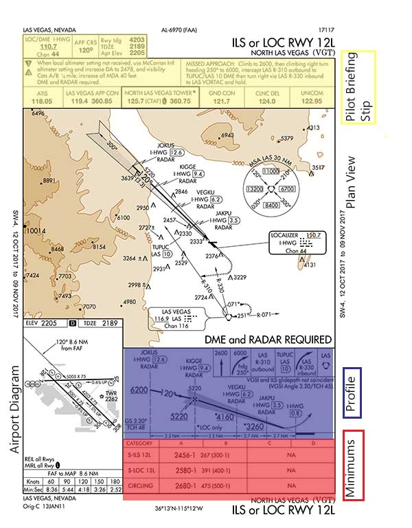 The first thing we look at is the Procedure ID and the City along with the Airport which is ILS for Runway 12L at North Las Vegas (VGT). The Briefing strip at the top gives us all the critical information including Com and Navigation (NAV)frequencies. Our NAV frequency to tune in will be 110.7 and our and COM will be a series of frequencies, so lets explain those. We need to listen to the Automatic Terminal Information Service (ATIS) this will provide information such as Altimeter setting and other important information, in this case the ATIS frequency is 118.05 so tune that to the COM a channel and listen when in range. Lets assume you have 2 COM radios, each capable of supporting 2 frequencies (Standby and Active), this will allow you to enter most frequencies needed before you commence the approach.
So the frequencies you will enter include the ATIS (118.05), Approach (119.4), Tower (125.7) and Ground Control (121.7) however if on hearing the ATIS an alternative frequency is given then you must use that instead.
The approach is depicted in both a Plan View and Profile. We can see that we will need to be vectored or Navigate to JOKUS which is 12.6 DME from the Localizer I-HWG. We must cross JOKUS no lower than 6200 ft. We fly a heading of 120 to intersect our next fix KIGGE which is 9.4 DME. Since we are flying a precision approach we intercept the glide slope (GS) illustrated by the "zigzag" line. That is we fly no lower than 5220 ft until we intercept the glide slope. The glide slope is indicated on your Primary Flight Display (PFD) or Course Deviation Indicator (CDI). The rest of the altitudes and distances are for the LOC or non precision approach and are not used if you are flying a precision approach with the use of a CDI.
The Minimums section of the IAP relates to the minimum altitude that you are able to descend without visual sight of the runway. For a precision approach we refer to this as the Decision Altitude (DA) as you make a decision to execute a missed approach or land when you reach this altitude. The columns A, B, C, D refer to your Aircraft approach category based on VREF. Lets assume we are flying an aircraft with a VREF of 95Kts which would be a Category B Aircraft. We can see that for the S-ILS 12L the DA is 2456ft. That is when you reach 2456 as you fly the approach you must have the runway in sight and determine it is safe to land. If not you will execute the missed approach procedure.
Missed Approach is shown in both the Briefing strip and depicted in both the Profile and Plan view. You will have already briefed the missed approach and know what to do before you commenced your approach. In this case you apply full power and climb to 2600ft then turn to a heading of 250 and in the turn continue to climb to 6000ft and intercept the LAS R-310. The LAS R-310 should have been entered into the NAV prior to commencing the approach, the frequency (116.9) is shown on the Plan View. R-310 is the 310 Radial from the Las Vegas (LAS) VOR.
Assuming you had the runway insight at the DA you would continue your approach and landing as normal.
Charts are available for download from various sites listed in the Resources section of our site.
This tutorial is intended for use with for flight simulation only and is not a substitute for flight or ground instruction from a flight instructor.